
Control of the occupancy of the landfill of the Mari El Republic using the results of aerial photography
DOI:
https://doi.org/10.24852/2411-7374.2024.1.30.38Keywords:
landfill, residual capacity, relief, remote monitoring, three-dimensional reconstruction, digital terrain modelAbstract
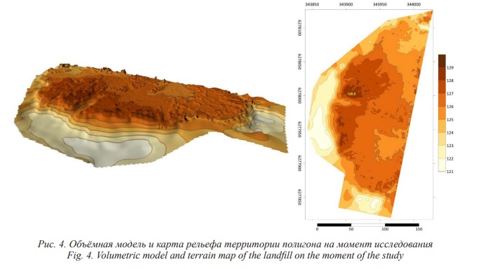
The paper presents an assessment of the residual capacity of a municipal solid waste landfill located in the Republic of Mari El. We used the method of comparative high-precision three-dimensional reconstruction of the design and actual relief of the landfill with the construction of its digital models based on the results of aerial photography of the territory. The landfill operates and is located in a spent clay quarry. The waste storage area is divided into two maps, the project provides for alternate filling of maps. The aboveground part of the polygon body is designed in the form of a truncated pyramid. Taking into account the forecasted filling conditions, the design capacity of the landfill is 380500 m3. To achieve our task, the DJI Phantom 4 unmanned aerial vehicle equipped with a receiver of the global satellite navigation system was used. The method of determining the residual capacity of the landfill consists in carrying out design data and the results of field surveys in one coordinate system and heights, it allows us to calculate the volume difference and assess the degree of fullness of the landfill. According to the data obtained, the actual area of the landfill burial area is less than the project one (3.5 ha) for 1.0 ha. The geometric characteristics of the polygon body also do not correspond to the design data. The volume of solid waste accumulated at the time of the survey (313204 m3) is less than that provided for by the project (380500 m3). The residual capacity of the test site was 67296 m3
References
Akhmetzyanova L.G., Usmanov D.M., Kuritsin I.N., Kuz'min R.S., Gafurov A.M. Otsenka ostatochnoj yomkosti poligona otkhodov s ispol’zovaniem dannykh BPLA [Assessment of the residual capacity of the landfill using UAV data] // Materials of the 65th International scientific conference of Astrakhan state technical university. Biology and Environmental Management section. Astrakhan, 2021. P. 155-158.
Akhmetzyanova L.G., Usmanov D.M., Gafurov A.M., Selivanova D.S. Primenenie distancionnogo metoda kontrolya, osnovannogo na ispol'zovanii dannyh BPLA, dlya ocenki ostatochnoj emkosti poligona othodov [The use of a remote control method based on UAV data to assess the residual capacity of a landfill] // Geopolitika i ekogeodinamika regionov [Geopolitics and ecogeodynamics of regions]. 2022. Vol. 8, iss. 4. P. 94–103. doi: 10.35634/2412-9518-2021-31-4-404-415
Viskov M.V. Izmenenie yomkosti massiva zakhoronenija otkhodov v protsesse expluatatsii ob’ektov zakhoronenija tverdykh kommunal’nykh otkhodov [Changing the capacity of the waste disposal array during the operation of municipal solid waste disposal facilities] // Vestnik PNPU. Prikladnaja ekologia. Urbanistika [Bulletin of PNRPU. Applied ecology. Urbanistics]. 2020. No 1. P. 126–134. doi: 10.15593/2409-5125/2020.01.10
GOST R 51833–2001. Fotogrammetriya. Terminy i opredeleniya [Photogrammetry. Terms and definitions].
GOST 32453–2017. Global'naya navigacionnaya sputnikovaya sistema. Sistemy koordinat. Metody preobrazovanij koordinat opredelyaemyh tochek. [Global navigation satellite system. Coordinate systems. Methods of transformation of coordinates of defined points].
GOST R 58854–2020. Fotogrammetriya. Trebovaniya k sozdaniyu orientirovannyh aerosnimkov dlya postroeniya stereomodelej zastroennyh territorij [Photogrammetry. Requirements for the creation of oriented aerial photographs for the construction of stereo models of built-up areas].
Mirnyj A.N., Murashov V.E., Koretskij V.E. Gosudarstvennoe upravlenie otkhodami v ramkakh kontseptsii ustojchivogo razvitija [State waste management within the framework of the concept of sustainable development. Moscow, 2012. 351 p.
O sostojanii b ob ohrane okruzhayushchej sredy Rossijskoj Federacii v 2021 godu. Gosudarstvennyj doklad [On the state and environmental protection of the Russian Federation in 2021. State report]. Moscow, 2022. 685 p.
Babu G., Kumar S., Reddy K.R. Approach for the use of MSW settlement predictions in the assessment of landfill capacity based on reliability analysis // Waste management. 2013. Vol. 33, No 10. Р. 2029–2034. doi: 10.1016/j.wasman.2013.05.018.
Baiocchi V. UAV for monitoring the settlement of a landfill // European journal of remote sensing. 2019. Vol. 52, No 3. Р. 41–52. doi: 10.1080/22797254.2019.1683471.
Bareither C.A., Benson C.H., Edil T.B. Compression behavior of municipal solid waste: immediate compression // Journal of geotechnical and geoenvironmental engineering. 2012. Vol. 138, No 9. P. 1047–1062. doi:10.1061/(ASCE)GT.1943-5606.0000672.
Chen Y.M., Zhan L.T., Wei H.Y., Ke H. Aging and compressibility of municipal solid wastes // Waste management. 2009. Vol. 29, No 1. Р. 86–95. doi: 10.1016/j.wasman.2008.02.024.
De F.B., Chanton J.P., Barlaz M.A. Measurement of carbon storage in landfills from the biogenic carbon content of excavated waste samples // Waste management. 2013. Vol. 33, No 10. Р. 2001–2005. doi: 10.1016/j.wasman.2012.12.012.
Esposito G.F., Matano F., Sacchi M. Detection and geometrical characterization of a buried landfill site by integrating land use historical analysis, digital photogrammetry and airborne lidar data // Geosciences. 2018. Vol. 8, No 9. 348. doi: 10.3390/geosciences8090348.
Gafurov A. The methodological aspects of constructing a high-resolution DEM of large territories using low-cost UAVs on the example of the Sarycum Aeolian complex, Dagestan, Russia // Drones. 2021. Vol. 5, iss.1. P. 1–17. doi: 10.3390/drones5010007.
Gafurov A., Yermolaev O., Usmanov B., Khomyakov P. Creation of high-precision digital elevation models using the GNSS UAV // InterCarto InterGIS. 2021. Т. 27, No 2. Р. 327–339. doi: 10.35595/2414-9179-2021-2-27-327-339
Gao W., Xu W., Bian X., Chen Y. A practical approach for calculating the settlement and storage capacity of landfills based on the space and time discretization of the landfilling process // Waste management. 2017. Vol. 69. Р. 202–214. doi: 10.1016/j.wasman.2017.07.048.
Gasperini D. Potential and limitation of UAV for monitoring subsidence in municipal landfills // International journal of environmental technology and management. 2014. Vol. 17, No 1. P. 1–13. doi: 10.1504/IJETM.2014.059456
Incekara A. Investigating the utility potential of low-cost unmanned aerial vehicles in the temporal monitoring of a landfill // ISPRS International Journal of Geo-Information. 2019. Vol. 8, №1. Р. 22. doi: 10.3390/ijgi8010022.
Mondal T., Choudhury M., Kundu D., Dutta D., Samanta P. Landfill: An eclectic review on structure, reactions and remediation approach // Waste management. 2023. Vol. 164. P. 127–142. doi: 10.1016/j.wasman.2023.03.034.
Santos J., Amaral L., Martinho G. Effects of landfill age, climate, and size on leachate from urban waste landfills in Portugal: A statistics and machine learning analysis // Waste management. 2023. Vol. 172. Р. 192–207. doi: 10.1016/j.wasman.2023.10.027.
Scheutz C., Samuelsson J., Fredenslund A.M., Kjeldsen P. Quantification of multiple methane emission sources at landfills using a double tracer technique // Waste management. 2011. Vol. 31, No 5. Р. 1009–1017. doi: 10.1016/j.wasman.2011.01.015.
Silva C.A., Duarte C.R., Souto M.V., Santos A.L., Amaro V.E., Bicho1 C.P., Sabadia J.A. Evaluating the accuracy in volume calculation in a pile of waste using UAV, GNSS and LiDAR // Boletim de ciências geodésicas. 2016.. Vol. 22, №1. Р. 73–94. doi: 10.1590/S1982-21702016000100005
Son S.W. Integrating UAV and TLS Approaches for environmental management: a case study of a Waste Stockpile Area // Remote sensing. 2020. Vol. 12, No 10. 1615. DOI: 10.3390/rs12101615
Tucci G. Monitoring and computation of the volumes of stockpiles of bulk material by means of UAV photogrammetric surveying // Remote sensing. 2019. Vol. 11, No 12. 1471. doi: 10.3390/rs11121471.
Yermolaev O.P., Usmanov B.M., Mishanina O.E., Khisamutdinova E.V. Basin approach to evaluation of human impact on the environment in oil production regions. // Neftyanoe khozyaistvo – Oil industry. 2014. Vol. 12. P. 156–160.
Yoo H.T. A preliminary study on disaster waste detection and volume estimation based on 3d spatial information // Computing in civil engineering 2017. Seattle, Washington: American Society of Civil Engineers, 2017. P. 428–435. doi: 10.1061/9780784480823.051
Downloads
Published
How to Cite
Issue
Section
License

This work is licensed under a Creative Commons Attribution-NonCommercial 4.0 International License.


